

SSC CGL Geography – Landforms – Mountains, Plateaus, Plains, Volcanoes & Earthquakes – Level 2 · Exam Level · Tier I Sprint
← Back
The two names are swapped in the statement.
₹599 →
SSC CGL Geography – Landforms – Mountains, Plateaus, Plains, Volcanoes & Earthquakes – Level 2 · Exam Level · Tier I Sprint – 15 questions, subject: Geography – India & World. Every question has the correct answer with a one-line explanation; tap "Show Answer". Free practice for TNPSC, UPSC, SSC, Bank and RRB exams – Shanmugam IAS Academy, Coimbatore.
Get daily current affairs & exam alerts – follow us
YouTube
WhatsApp Channel
Telegram Channel
Facebook Page
Instagram
Share with friends & study groups
Link to this page from your website / blog (HTML code)
1.
Statement-basedConsider:
I. Weathering includes the transport of rock material.
II. Exfoliation is common in hot deserts.
Which is/are correct?
I. Weathering includes the transport of rock material.
II. Exfoliation is common in hot deserts.
Which is/are correct?
Correct Answer: A [Only II]
Explanation:
Weathering is in place (no transport); exfoliation comes from daily heating and cooling.
2.
Match the followingMatch the volcano with its country:
P. Krakatoa Q. Etna R. Cotopaxi S. Mount St Helens
1. USA 2. Ecuador 3. Indonesia 4. Italy
P. Krakatoa Q. Etna R. Cotopaxi S. Mount St Helens
1. USA 2. Ecuador 3. Indonesia 4. Italy
Correct Answer: C [P-3, Q-4, R-2, S-1]
Explanation:
Krakatoa – Indonesia (1883); Etna – Sicily, Italy; Cotopaxi – Ecuador; Mount St Helens – USA (1980).
3.
Diagram-basedThe figure shows folded rock layers. Which labelled part is a syncline?
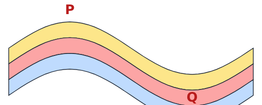
Correct Answer: B [Q]
Explanation:
Q is the down-fold (trough) = syncline; P is the up-fold = anticline.
4.
Chronological orderArrange in chronological order: Plate tectonics, Hess's sea-floor spreading, Wegener's continental drift, Holmes's convection currents
Correct Answer: D [Wegener's continental drift, Holmes's convection currents, Hess's sea-floor spreading, Plate tectonics]
Explanation:
1912 → 1930s → early 1960s → 1967.
5.
Odd one outVosges, Black Forest, Andes, Satpura
Correct Answer: A [Andes]
Explanation:
The Andes are young fold mountains; the Vosges, Black Forest and Satpura are block mountains.
6.
Assertion–Reason
A: The Himalaya have very few active volcanoes.
R: Where two continental plates collide, neither sinks deep into the mantle.
A: The Himalaya have very few active volcanoes.
R: Where two continental plates collide, neither sinks deep into the mantle.
Correct Answer: C [Both A and R are true and R explains A]
Explanation:
No deep subduction → little melting → few volcanoes.
7.
How many statements are trueHow many of these statements are true?
I. A sill is a horizontal sheet of igneous rock.
II. A dyke is a vertical sheet.
III. A batholith forms on the surface.
IV. A laccolith is dome-shaped.
I. A sill is a horizontal sheet of igneous rock.
II. A dyke is a vertical sheet.
III. A batholith forms on the surface.
IV. A laccolith is dome-shaped.
Correct Answer: B [3]
Explanation:
III is false – a batholith is a huge body deep inside the crust.
8.
An ox-bow lake is formed by a:
Correct Answer: D [river]
Explanation:
It is a cut-off meander on a plain.
9.
Which pair (agent – landform) is correctly matched?
Correct Answer: B [Glacier – drumlin]
Explanation:
Levee: river; barchan: wind; esker: glacier.
10.
Two-quantity comparison
Quantity I: ratio of wave amplitudes of earthquakes of magnitude 7 and 5
Quantity II: 100
Quantity I: ratio of wave amplitudes of earthquakes of magnitude 7 and 5
Quantity II: 100
Correct Answer: C [Quantity I = Quantity II]
Explanation:
Two steps → 10 × 10 = 100.
11.
Diagram-basedThe figure shows two plates colliding (arrows show motion). Which kind of boundary is it?
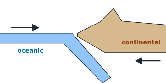
Correct Answer: A [Ocean–continent convergent]
Explanation:
The oceanic plate (left) sinks under the continental plate (right) – ocean–continent convergence.
12.
Gold deposits on the Ghana coast with no source rock nearby are used as evidence for:
Correct Answer: C [continental drift]
Explanation:
Placer gold: the source rock lies in Brazil, once joined to Africa.
13.
Which is an example of a rift valley formed where plates pull apart?
Correct Answer: D [East African Rift Valley]
Explanation:
Divergent boundary on land.
14.
Reverse question“I am a crescent-shaped sand dune whose horns point downwind.” What am I?
Correct Answer: C [Barchan]
Explanation:
Seif = long ridge; loess = wind-blown dust; moraine = glacial debris.
15.
Spot My Mistake“The Mercalli scale measures the energy released, while the Richter scale measures the damage caused.” What is correct?
Correct Answer: B [Richter measures magnitude (energy); Mercalli measures intensity (damage)]
Explanation:
The two names are swapped in the statement.
➤ Full notes, shortcuts and every answer explained – SSC CGL 2026 Geography – India & World book (₹149): www.shanmugamiasacademy.in/study-materials/ssc-cgl-geography-india-world
📘 TNPSC பொது அறிவு அலகு II — இந்தியாவின் புவியியல் (Geography of India) – முழுமையான பாடநூல்
Here you get the answer with a one-line explanation. TNPSC பொது அறிவு அலகு II இந்தியப் புவியியல் முழுவதும் · 14 அத்தியாயங்கள் · 340 பயிற்சி வினாக்கள் விளக்கத்துடன் · 2 மாதிரித் தேர்வுகள் (100 வினாக்கள்) · வரைபடங்கள், 14 மனவரைபடங்கள் · ஒவ்வோர் அத்தியாயத்திலும் தமிழ்நாடு பார்வை
Get the book – ₹299 More quizzes
› SSC CGL Geography – Mock Test 3 – Tier II Style – Mock Test 3 · Tier II Style
› SSC CGL Geography – Mock Test 2 – Tier I Style – Mock Test 2 · Tier I Style
› SSC CGL Geography – Mock Test 1 – Tier I Style – Mock Test 1 · Tier I Style
› SSC CGL Geography – Environment, Ecology & Climate Change – Tier II Level · Marathon
› SSC CGL Geography – Environment, Ecology & Climate Change – Level 3 · Challenge
› SSC CGL Geography – Environment, Ecology & Climate Change – Level 2 · Exam Level · Tier I Sprint
Score: 0
Answered: 0 / 0
