

SSC CGL Geography – India – Location, Size & Physiography – Level 2 · Exam Level · Tier I Sprint
← Back
82°30′E, Uttar Pradesh.
₹599 →
SSC CGL Geography – India – Location, Size & Physiography – Level 2 · Exam Level · Tier I Sprint – 15 questions, subject: Geography – India & World. Every question has the correct answer with a one-line explanation; tap "Show Answer". Free practice for TNPSC, UPSC, SSC, Bank and RRB exams – Shanmugam IAS Academy, Coimbatore.
Get daily current affairs & exam alerts – follow us
YouTube
WhatsApp Channel
Telegram Channel
Facebook Page
Instagram
Share with friends & study groups
Link to this page from your website / blog (HTML code)
1.
Statement-basedConsider:
I. The Shiwaliks are the southernmost range of the Himalaya.
II. The Pir Panjal range belongs to the Himadri.
Which is/are correct?
I. The Shiwaliks are the southernmost range of the Himalaya.
II. The Pir Panjal range belongs to the Himadri.
Which is/are correct?
Correct Answer: A [Only I]
Explanation:
Pir Panjal belongs to the Himachal (Lesser Himalaya).
2.
Match the followingMatch:
P. Himadri Q. Himachal R. Shiwalik S. Purvachal
1. Mizo hills 2. Highest peaks 3. Pir Panjal range 4. Unconsolidated sediments
P. Himadri Q. Himachal R. Shiwalik S. Purvachal
1. Mizo hills 2. Highest peaks 3. Pir Panjal range 4. Unconsolidated sediments
Correct Answer: D [P-2, Q-3, R-4, S-1]
Explanation:
Himadri High, Himachal Hill-station, Shiwalik Short.
3.
Diagram-basedThe figure shows the three parallel ranges of the Himalaya from north to south. Which range is marked '?'
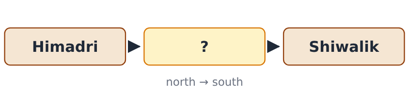
Correct Answer: B [Himachal]
Explanation:
Himadri → Himachal → Shiwalik.
4.
Arrange in orderArrange the Himalayan ranges from north to south: Shiwalik, Himadri, Himachal
Correct Answer: C [Himadri, Himachal, Shiwalik]
Explanation:
Height falls towards the plains.
5.
Odd one outOdd one out (states crossed by the 82°30′E meridian): Uttar Pradesh, Bihar, Chhattisgarh, Odisha
Correct Answer: B [Bihar]
Explanation:
82°30′E crosses UP, MP, Chhattisgarh, Odisha and Andhra Pradesh – not Bihar.
6.
Assertion–Reason
A: Most Peninsular rivers flow east into the Bay of Bengal.
R: The Deccan Plateau slopes gently towards the east.
A: Most Peninsular rivers flow east into the Bay of Bengal.
R: The Deccan Plateau slopes gently towards the east.
Correct Answer: D [Both A and R are true and R explains A]
Explanation:
The eastward slope decides the flow.
7.
How many statements are trueHow many of these statements are true?
I. Bhangar is older alluvium.
II. Khadar contains kankar nodules.
III. Streams disappear in the Bhabar belt.
IV. The Terai is a wet, swampy belt.
I. Bhangar is older alluvium.
II. Khadar contains kankar nodules.
III. Streams disappear in the Bhabar belt.
IV. The Terai is a wet, swampy belt.
Correct Answer: A [3]
Explanation:
II is false – kankar is found in the Bhangar.
8.
Which pass is correctly matched with the places it links?
Correct Answer: C [Zoji La – Srinagar and Leh]
Explanation:
Banihal: Jammu–Srinagar; Rohtang: Manali–Lahaul; Nathu La: Sikkim–Tibet.
9.
Diagram-basedThe figure shows two rivers of Punjab. Which doab lies between them?

Correct Answer: B [Chaj Doab]
Explanation:
Cha-j = Chenab + Jhelum.
10.
Reverse question“I separate Minicoy from the Maldives.” Which channel am I?
Correct Answer: C [Eight Degree Channel]
Explanation:
9 and 8 Guard Minicoy – 8 faces the Maldives.
11.
Spot My Mistake“Chilika lake lies on the Malabar coast in Keralam.” What is correct?
Correct Answer: D [Chilika lies on the east coast, in Odisha]
Explanation:
Vembanad is the Keralam backwater.
12.
The older alluvium of the Northern Plains, lying above the flood plains and often with kankar nodules, is called:
Correct Answer: A [Bhangar]
Explanation:
Bhangar = old alluvium; khadar = new flood-plain alluvium.
13.
Two-quantity comparison
Quantity I: India's latitudinal extent (8°4′N–37°6′N)
Quantity II: India's longitudinal extent (68°7′E–97°25′E)
Quantity I: India's latitudinal extent (8°4′N–37°6′N)
Quantity II: India's longitudinal extent (68°7′E–97°25′E)
Correct Answer: B [Quantity I < Quantity II]
Explanation:
29°2′ < 29°18′.
14.
The Western and the Eastern Ghats meet in the:
Correct Answer: A [Nilgiri hills]
Explanation:
Doda Betta is the peak of the Nilgiris.
15.
The standard meridian of India passes near:
Correct Answer: D [Mirzapur]
Explanation:
82°30′E, Uttar Pradesh.
➤ Full notes, shortcuts and every answer explained – SSC CGL 2026 Geography – India & World book (₹149): www.shanmugamiasacademy.in/study-materials/ssc-cgl-geography-india-world
📘 TNPSC பொது அறிவு அலகு II — இந்தியாவின் புவியியல் (Geography of India) – முழுமையான பாடநூல்
Here you get the answer with a one-line explanation. TNPSC பொது அறிவு அலகு II இந்தியப் புவியியல் முழுவதும் · 14 அத்தியாயங்கள் · 340 பயிற்சி வினாக்கள் விளக்கத்துடன் · 2 மாதிரித் தேர்வுகள் (100 வினாக்கள்) · வரைபடங்கள், 14 மனவரைபடங்கள் · ஒவ்வோர் அத்தியாயத்திலும் தமிழ்நாடு பார்வை
Get the book – ₹299 More quizzes
› SSC CGL Geography – Mock Test 3 – Tier II Style – Mock Test 3 · Tier II Style
› SSC CGL Geography – Mock Test 2 – Tier I Style – Mock Test 2 · Tier I Style
› SSC CGL Geography – Mock Test 1 – Tier I Style – Mock Test 1 · Tier I Style
› SSC CGL Geography – Environment, Ecology & Climate Change – Tier II Level · Marathon
› SSC CGL Geography – Environment, Ecology & Climate Change – Level 3 · Challenge
› SSC CGL Geography – Environment, Ecology & Climate Change – Level 2 · Exam Level · Tier I Sprint
Score: 0
Answered: 0 / 0
