

SSC CGL Geography – Drainage System of India – Level 2 · Exam Level · Tier I Sprint
← Back
Inward = centripetal; outward = radial.
₹599 →
SSC CGL Geography – Drainage System of India – Level 2 · Exam Level · Tier I Sprint – 15 questions, subject: Geography – India & World. Every question has the correct answer with a one-line explanation; tap "Show Answer". Free practice for TNPSC, UPSC, SSC, Bank and RRB exams – Shanmugam IAS Academy, Coimbatore.
Get daily current affairs & exam alerts – follow us
YouTube
WhatsApp Channel
Telegram Channel
Facebook Page
Instagram
Share with friends & study groups
Link to this page from your website / blog (HTML code)
1.
Statement-basedConsider:
I. The Narmada flows in a rift valley between the Vindhya and the Satpura.
II. The Tapi forms a large delta.
Which is/are correct?
I. The Narmada flows in a rift valley between the Vindhya and the Satpura.
II. The Tapi forms a large delta.
Which is/are correct?
Correct Answer: D [Only I]
Explanation:
The Tapi ends in an estuary.
2.
Match the followingMatch:
P. Bhakra Nangal Q. Sardar Sarovar R. Mettur S. Nagarjuna Sagar
1. Krishna 2. Kaveri 3. Satluj 4. Narmada
P. Bhakra Nangal Q. Sardar Sarovar R. Mettur S. Nagarjuna Sagar
1. Krishna 2. Kaveri 3. Satluj 4. Narmada
Correct Answer: B [P-3, Q-4, R-2, S-1]
Explanation:
Bhakra Satluj, Sardar Narmada, Mettur Kaveri, Nagarjuna Krishna.
3.
Diagram-basedThe figure shows the five prayags along the Alaknanda. Which prayag is marked '?'

Correct Answer: C [Rudraprayag]
Explanation:
Very Nice Kids Run Daily – the fourth is Rudraprayag.
4.
Arrange in orderArrange from upstream to downstream: Rudraprayag, Vishnuprayag, Devprayag, Karnaprayag
Correct Answer: A [Vishnuprayag, Karnaprayag, Rudraprayag, Devprayag]
Explanation:
Very Nice Kids Run Daily.
5.
Odd one outMahanadi, Godavari, Tapi, Kaveri
Correct Answer: A [Tapi]
Explanation:
The Tapi flows west into the Arabian Sea (estuary); the others flow east and form deltas.
6.
Assertion–Reason
A: The Narmada does not form a delta.
R: It flows through a narrow rift valley and carries its load out to sea.
A: The Narmada does not form a delta.
R: It flows through a narrow rift valley and carries its load out to sea.
Correct Answer: C [Both A and R are true and R explains A]
Explanation:
East Delta, West Estuary.
7.
How many statements are trueHow many of these statements are true?
I. Wular lake is in Jammu & Kashmir.
II. Chilika lake is in Keralam.
III. Sambhar is a salt lake.
IV. Gobind Sagar is an artificial lake.
I. Wular lake is in Jammu & Kashmir.
II. Chilika lake is in Keralam.
III. Sambhar is a salt lake.
IV. Gobind Sagar is an artificial lake.
Correct Answer: D [3]
Explanation:
II is false – Chilika is in Odisha.
8.
Which city–river pair is correctly matched?
Correct Answer: B [Ahmedabad – Sabarmati]
Explanation:
Surat – Tapi; Cuttack – Mahanadi; Lucknow – Gomti.
9.
Diagram-basedIn the figure, tributary X flows from the south and joins the Ganga directly. Which river can X be?
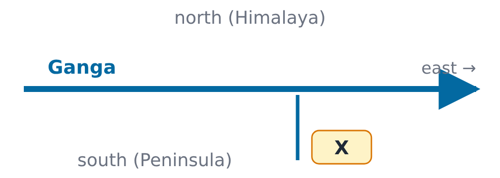
Correct Answer: A [Son]
Explanation:
The Gandak and Kosi come from the north; the Chambal joins the Yamuna.
10.
Reverse question“I rise from a spring at Verinag and flow through Srinagar and the Wular lake.” Which river am I?
Correct Answer: C [Jhelum]
Explanation:
A tributary of the Indus.
11.
Spot My Mistake“The Chambal joins the Ganga directly at Prayagraj.” What is correct?
Correct Answer: B [The Chambal joins the Yamuna]
Explanation:
Chambal, Betwa and Ken join the Yamuna.
12.
Arrange in orderArrange in decreasing order of length (NCERT values): Kaveri, Godavari, Mahanadi, Krishna
Correct Answer: D [Godavari, Krishna, Mahanadi, Kaveri]
Explanation:
Go-Kri-Ma-Ka.
13.
Two-quantity comparison
Quantity I: length of the Godavari + length of the Krishna (NCERT values)
Quantity II: length of the Indus (NCERT value)
Quantity I: length of the Godavari + length of the Krishna (NCERT values)
Quantity II: length of the Indus (NCERT value)
Correct Answer: C [Quantity I = Quantity II]
Explanation:
1,500 + 1,400 = 2,900 = Indus.
14.
Majuli, the largest inhabited riverine island, lies in the:
Correct Answer: C [Brahmaputra]
Explanation:
In Assam.
15.
Streams flowing into Loktak lake from all directions are an example of which drainage pattern?
Correct Answer: A [Centripetal]
Explanation:
Inward = centripetal; outward = radial.
➤ Full notes, shortcuts and every answer explained – SSC CGL 2026 Geography – India & World book (₹149): www.shanmugamiasacademy.in/study-materials/ssc-cgl-geography-india-world
📘 TNPSC பொது அறிவு அலகு II — இந்தியாவின் புவியியல் (Geography of India) – முழுமையான பாடநூல்
Here you get the answer with a one-line explanation. TNPSC பொது அறிவு அலகு II இந்தியப் புவியியல் முழுவதும் · 14 அத்தியாயங்கள் · 340 பயிற்சி வினாக்கள் விளக்கத்துடன் · 2 மாதிரித் தேர்வுகள் (100 வினாக்கள்) · வரைபடங்கள், 14 மனவரைபடங்கள் · ஒவ்வோர் அத்தியாயத்திலும் தமிழ்நாடு பார்வை
Get the book – ₹299 More quizzes
› SSC CGL Geography – Mock Test 3 – Tier II Style – Mock Test 3 · Tier II Style
› SSC CGL Geography – Mock Test 2 – Tier I Style – Mock Test 2 · Tier I Style
› SSC CGL Geography – Mock Test 1 – Tier I Style – Mock Test 1 · Tier I Style
› SSC CGL Geography – Environment, Ecology & Climate Change – Tier II Level · Marathon
› SSC CGL Geography – Environment, Ecology & Climate Change – Level 3 · Challenge
› SSC CGL Geography – Environment, Ecology & Climate Change – Level 2 · Exam Level · Tier I Sprint
Score: 0
Answered: 0 / 0
